I’m getting into the race-specific-training portion of my training plan for the Honor Run Half Marathon. I have a slight issue, I need to do a run while on a business trip to another part of the country. Fortunately, I know some people in the destination city and dropped them an email confirming where I think I can run 11 miles and see what the weather should be like.
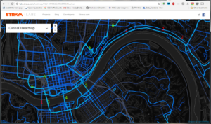
So I panned over to Cincinnati and took a look at things. There’s some bright areas that are on the map (some brightly lit) that aren’t great places to run… and of course some are there because they are.

Guide:
- Brent Spence Bridge (I-71/75). Pedestrians not allowed, and violating that would be deadly. There is no way the tracks here could be from runners, because none of them end up in the water (don’t laugh, it happened).
- Columbia Parkway. Pedestrians not allowed, but closed to the Heart Mini Marathon (half marathon) yearly, so the track is likely runners, but during an event.
- Clay Wade Bailey Bridge. There’s a walkway on the east side of the bridge, and it’s common for runners.
- Roebling Suspension Bridge. The prototype for the Brooklyn Bridge, and my favorite bridge to cross during sunrise. Walkways are on both sides, but the sunrise from the east is the best.
- Purple People Bridge. As the name implies, no cars!
- Flying Pig Marathon and Half Marathon course. I’ve run this area many times while not in The Pig. It’s easier when the roads are closed, but the sidewalks are fine through this area. Just stay off the ramp from Gilbert to 7th Street (it’ll be obvious from the lack of sidewalks and cars coming straight at you)
Run Well!
